Before they settled down in various parts of the world, humans lived as nomads for tens of thousands of years. Nomads are people who have no permanent home and travel in search of food and safety.
A typical nomadic group might include an extended family of about ten adults and their children. They would temporarily camp in an area for a few weeks or months — the men hunting animals and the women gathering fruit, grains, seeds, and nuts. When the nomads exhausted the resources in that area they moved on.
Civilization developed slowly in different parts of the world. People began to settle in areas with abundant natural resources. For thousands of years, people have been attracted to a part of the world archaeologists later called the Fertile Crescent.
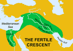
Fertile_creacent_Map_Small
The Fertile Crescent is a boomerang-shaped region that extends from the eastern shore of the Mediterranean Sea to the Persian Gulf. The Fertile Crescent is a rich food-growing area in a part of the world where most of the land is too dry for farming. (Click here for a larger map )
The Fertile Crescent is a boomerang-shaped region that extends from the eastern shore of the Mediterranean Sea to the Persian Gulf. It is a rich food-growing area in a part of the world where most of the land is too dry for farming.
Some of the best farmland of the Fertile Crescent is on a narrow strip of land between the Tigris and the Euphrates Rivers. The two rivers travel in the same direction for thousands of miles before they combine to drain into the Persian Gulf. The Greeks called this area Mesopotamia, which means “between the rivers.” Very little rain falls in Mesopotamia, but water and nutrients from the river soak into the land, creating an environment filled with plants and the animals that feed on the vegetation.
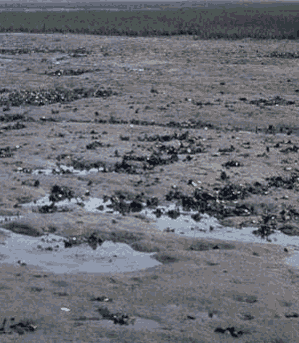
Mesopotamia_mud
The muddy, swampy land between the Tigris and the Euphrates rivers provided the natural resources that encouraged people to settle in one place.
Many different civilizations flourished in this small region. The Sumerians slowly developed one of the first civilizations in the southeastern region of Mesopotamia as long as 7,500 years ago. The Sumerian civilization lasted more than three thousand years, but in time the Sumerians lost their influence. The Babylonians formed a centralized government under King Hammurabi from about 1770BCE to about 1595BCE. Various other cultures dominated part or all of the Fertile Crescent including Amorites, the Kassites, (c. 1531-1155BCE) the Hittites (c. 1370 – 1205BCE) and the Assyrians (c.890-600BCE). Mesopotamia was later controlled by the Persians of modern day Iran, the Greeks under Alexander the Great, the Romans, and the Ottoman Turks. The land between the Tigris and Euphrates has been part of the modern nation of Iraq since 1932.
Resources
Download this lesson as Microsoft Word file or as an Adobe Acrobat file.
Listen as Mr. Dowling reads this lesson.
View the Powerpoint Presentation of this lesson.
Download a lesson plan that includes the Florida Next Generation Sunshine State Standards (2011) as a Microsoft Word file or as an Adobe Acrobat file.
Mr. Donn has an excellent website that includes a section on Mesopotamia.
Natural Boundaries
The Tigris and the Euphrates are natural boundaries. This is because the region’s borders were formed by nature instead of being drawn by people. Examples of natural boundaries include rivers, mountain ranges, and deserts.
Straight lines on a map generally signify borders made by people, while natural borders can follow many different paths. This is easy to demonstrate on a map of the United States. Most of the boundaries of the western states are straight lines; Colorado and Wyoming and rectangles. Many eastern states have jagged shapes because rivers form their borders.


